
Make a donation
Gear up for your next adventure:
As an Amazon Associate, this site earns from qualifying purchases at no extra cost to you.
Nambour topographic map
Click on the map to display elevation.
Make a donation
Gear up for your next adventure:
As an Amazon Associate, this site earns from qualifying purchases at no extra cost to you.
About this map
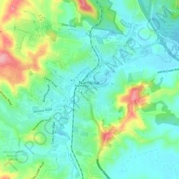
Name: Nambour topographic map, elevation, terrain.
Average elevation: 135 ft
Minimum elevation: 7 ft
Maximum elevation: 446 ft
Make a donation
Gear up for your next adventure:
As an Amazon Associate, this site earns from qualifying purchases at no extra cost to you.
Other topographic maps
Click on a map to view its topography, its elevation and its terrain.
Sunshine Coast
Australia > Queensland > Sunshine Coast Regional
The Sunshine Coast in Queensland, Australia, showcases a diverse topography that harmoniously blends coastal plains with rugged hinterlands. Along its eastern edge, the region features expansive sandy beaches and coastal dunes that transition smoothly into fertile lowlands. Inland, the terrain becomes more…
Average elevation: 358 ft
Caloundra
Australia > Queensland > Sunshine Coast Regional
Caloundra, located on Queensland's Sunshine Coast, features a diverse coastal topography characterized by sandy beaches, rocky headlands, and nearby elevated terrains. The suburb of Kings Beach exemplifies this diversity, with its sandy shoreline to the south and southeast, and a rocky headland rising to about…
Average elevation: 16 ft
Make a donation
Gear up for your next adventure:
As an Amazon Associate, this site earns from qualifying purchases at no extra cost to you.
Make a donation
Gear up for your next adventure:
As an Amazon Associate, this site earns from qualifying purchases at no extra cost to you.
Make a donation
Gear up for your next adventure:
As an Amazon Associate, this site earns from qualifying purchases at no extra cost to you.
Make a donation
Gear up for your next adventure:
As an Amazon Associate, this site earns from qualifying purchases at no extra cost to you.
Make a donation
Gear up for your next adventure:
As an Amazon Associate, this site earns from qualifying purchases at no extra cost to you.
Glass House Mountain Lookout
Australia > Queensland > Sunshine Coast Regional
Average elevation: 276 ft
Make a donation
Gear up for your next adventure:
As an Amazon Associate, this site earns from qualifying purchases at no extra cost to you.
Caloundra
Australia > Queensland > Sunshine Coast Regional
Caloundra, located on Queensland's Sunshine Coast, features a diverse coastal topography characterized by sandy beaches, rocky headlands, and nearby elevated terrains. The suburb of Kings Beach exemplifies this diversity, with its sandy shoreline to the south and southeast, and a rocky headland rising to about…
Average elevation: 16 ft
Make a donation
Gear up for your next adventure:
As an Amazon Associate, this site earns from qualifying purchases at no extra cost to you.
Make a donation
Gear up for your next adventure:
As an Amazon Associate, this site earns from qualifying purchases at no extra cost to you.
Caloundra
Australia > Queensland > Sunshine Coast Regional
Caloundra, located on Queensland's Sunshine Coast, features a diverse coastal topography characterized by sandy beaches, rocky headlands, and nearby elevated terrains. The suburb of Kings Beach exemplifies this diversity, with its sandy shoreline to the south and southeast, and a rocky headland rising to about…
Average elevation: 16 ft