
Thank you for supporting this site ❤️
Make a donation
Make a donation
Gear up for your next adventure:
As an Amazon Associate, this site earns from qualifying purchases at no extra cost to you.
Charallave topographic map
Click on the map to display elevation.
Thank you for supporting this site ❤️
Make a donation
Make a donation
Gear up for your next adventure:
As an Amazon Associate, this site earns from qualifying purchases at no extra cost to you.
About this map
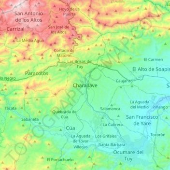
Name: Charallave topographic map, elevation, terrain.
Location: Charallave, Municipio Cristóbal Rojas, Miranda, Venezuela (10.08566 -67.01866 10.40566 -66.69866)
Average elevation: 1,864 ft
Minimum elevation: 413 ft
Maximum elevation: 5,663 ft
Thank you for supporting this site ❤️
Make a donation
Make a donation
Gear up for your next adventure:
As an Amazon Associate, this site earns from qualifying purchases at no extra cost to you.