
Wenzhou topographic map
Interactive map
Click on the map to display elevation.
About this map
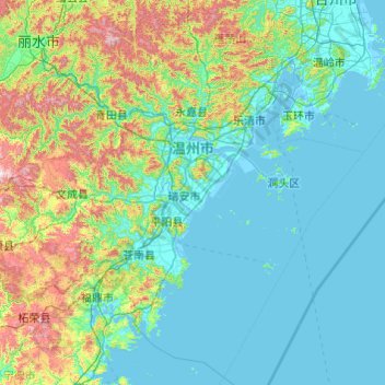
Name: Wenzhou topographic map, elevation, terrain.
Location: Wenzhou, Zhejiang, Chine (26.96481 119.62023 28.61525 121.55736)
Average elevation: 712 ft
Minimum elevation: -13 ft
Maximum elevation: 4,865 ft
Other topographic maps
Click on a map to view its topography, its elevation and its terrain.
District d'Ouhai
District d'Ouhai, Wenzhou, Zhejiang, 325006, Chine
Average elevation: 476 ft
Xian de Shengsi
Xian de Shengsi, Zhoushan, 嵊泗县, Zhejiang, 202450, Chine
Average elevation: 7 ft
MenTou
Chine > Zhejiang > Xian de Xiangshan
MenTou, Xian de Xiangshan, Ningbo, Zhejiang, Chine
Average elevation: 33 ft
红旗塘
Chine > Zhejiang > District de Xiuzhou
红旗塘, District de Xiuzhou, Jiaxing, Zhejiang, Chine
Average elevation: 10 ft
Lac de l'Ouest
Lac de l'Ouest, 孤山路, 北山街道, 西湖区, 西湖区 (Xihu), Hangzhou, Zhejiang, 31007, Chine
Average elevation: 62 ft