
Krumë topographic map
Interactive map
Click on the map to display elevation.
About this map
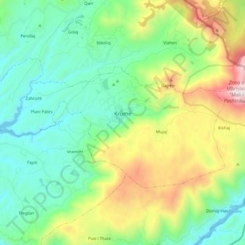
Name: Krumë topographic map, elevation, terrain.
Average elevation: 2,507 ft
Minimum elevation: 919 ft
Maximum elevation: 6,414 ft
Krumë is located at about 430 m above sea level. It is a small town at the north-west foot of the Bjeshka e Krumes mountain (English: Kruma Highland, Mount of Kruma), from which comes a large source of underground water called Vrella with clean and cool water serving the domestic population's needs for fresh water. Maja e Gjytezës, a mountain located few kilometers south of Krumë reaches an altitude of 1435 m above sea level.
Other topographic maps
Click on a map to view its topography, its elevation and its terrain.
Bashkia Kukës
Albania > Northern Albania > Kukës County
Bashkia Kukës, Kukës County, Northern Albania, Albania
Average elevation: 3,468 ft
Pakisht
Albania > Northern Albania > Kukës County > Bashkia Kukës
Pakisht, Bashkia Kukës, Kukës County, Northern Albania, 8515, Albania
Average elevation: 3,809 ft
Kukës
Albania > Northern Albania > Kukës County > Bashkia Kukës
Kukës, Bashkia Kukës, Kukës County, Northern Albania, 8501, Albania
Average elevation: 1,142 ft