
Make a donation
Gear up for your next adventure:
As an Amazon Associate, this site earns from qualifying purchases at no extra cost to you.
Surheide topographic map
Click on the map to display elevation.
Make a donation
Gear up for your next adventure:
As an Amazon Associate, this site earns from qualifying purchases at no extra cost to you.
Surheide
Der Stadtteil Surheide liegt im Südosten der Stadt und grenzt im Westen an die Stadtteile Wulsdorf und Geestemünde, im Norden an den Stadtteil Schiffdorferdamm sowie im Osten und Süden an die niedersächsischen Gemeinden Schiffdorf und Loxstedt. Die Höhe 7,5 m ü. NHN wird an der Schule erreicht.
Make a donation
Gear up for your next adventure:
As an Amazon Associate, this site earns from qualifying purchases at no extra cost to you.
About this map
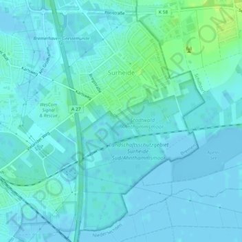
Name: Surheide topographic map, elevation, terrain.
Average elevation: 10 ft
Minimum elevation: -13 ft
Maximum elevation: 43 ft
Make a donation
Gear up for your next adventure:
As an Amazon Associate, this site earns from qualifying purchases at no extra cost to you.
Other topographic maps
Click on a map to view its topography, its elevation and its terrain.