Geolocate

Pendell topographic map

Click on the map to display elevation.

About this map

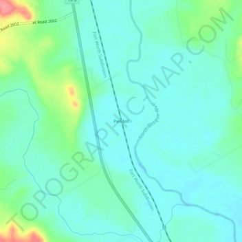
Name: Pendell topographic map, elevation, terrain.

Location: Pendell, Bosque County, Texas, United States (31.69377 -97.56141 31.73377 -97.52141)

Average elevation: 640 ft

Minimum elevation: 577 ft

Maximum elevation: 850 ft

Bosque County trails, hiking, mountain biking, running and outdoor activities

Other topographic maps

Click on a map to view its topography, its elevation and its terrain.

Walnut Springs

United States > Texas > Bosque County

Average elevation: 942 ft

Cranfills Gap

United States > Texas > Bosque County

Average elevation: 997 ft

Iredell

United States > Texas > Bosque County

Average elevation: 912 ft

Meridian

United States > Texas > Bosque County

Average elevation: 804 ft

Morgan

United States > Texas > Bosque County

Average elevation: 745 ft

Clifton

United States > Texas > Bosque County

Average elevation: 715 ft

Gear up for your next adventure:

🧥Waterproof Jacket for Hiking - Breathable and rugged rain jacket for outdoor excursions
🥾Women's Hiking Boots - Top-rated trail boots with ankle support and superior grip
☀️Outdoor Sunscreen - High protection sunscreen for outdoor activities
📦Gear Storage Bags - Organize and protect outdoor equipment
🧤Hiking Gloves - Protective gloves for rugged trails

As an Amazon Associate, this site earns from qualifying purchases at no extra cost to you.