
Maysville topographic map
Interactive map
Click on the map to display elevation.
About this map
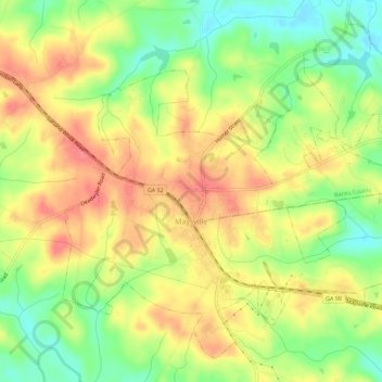
Name: Maysville topographic map, elevation, terrain.
Location: Maysville, Banks County, Georgia, 30558, United States (34.23614 -83.58047 34.27690 -83.52429)
Average elevation: 856 ft
Minimum elevation: 722 ft
Maximum elevation: 971 ft
Other topographic maps
Click on a map to view its topography, its elevation and its terrain.
Pinefield Crossroads
United States > Georgia > Banks County
Pinefield Crossroads, Banks County, Georgia, United States
Average elevation: 896 ft
Homer
United States > Georgia > Banks County
Homer, Banks County, Georgia, 30547, United States
Average elevation: 801 ft
Alto
United States > Georgia > Banks County > Alto
Alto, Banks County, Georgia, 30510, United States
Average elevation: 1,325 ft
Gillsville
United States > Georgia > Banks County
Gillsville, Banks County, Georgia, United States
Average elevation: 912 ft