
Make a donation
Gear up for your next adventure:
As an Amazon Associate, this site earns from qualifying purchases at no extra cost to you.
Rollinsford topographic map
Click on the map to display elevation.
Make a donation
Gear up for your next adventure:
As an Amazon Associate, this site earns from qualifying purchases at no extra cost to you.
About this map
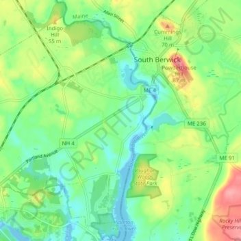
Name: Rollinsford topographic map, elevation, terrain.
Average elevation: 105 ft
Minimum elevation: -30 ft
Maximum elevation: 295 ft
Make a donation
Gear up for your next adventure:
As an Amazon Associate, this site earns from qualifying purchases at no extra cost to you.
Other topographic maps
Click on a map to view its topography, its elevation and its terrain.
Center Strafford
United States > New Hampshire > Strafford County > Strafford
Average elevation: 486 ft
New Durham Corner
United States > New Hampshire > Strafford County > New Durham
Average elevation: 604 ft
Make a donation
Gear up for your next adventure:
As an Amazon Associate, this site earns from qualifying purchases at no extra cost to you.
Bow Lake Village
United States > New Hampshire > Strafford County > Strafford
Average elevation: 571 ft
Make a donation
Gear up for your next adventure:
As an Amazon Associate, this site earns from qualifying purchases at no extra cost to you.