
Thank you for supporting this site ❤️
Make a donation
Make a donation
Gear up for your next adventure:
As an Amazon Associate, this site earns from qualifying purchases at no extra cost to you.
Mường Lay topographic map
Click on the map to display elevation.
Thank you for supporting this site ❤️
Make a donation
Make a donation
Gear up for your next adventure:
As an Amazon Associate, this site earns from qualifying purchases at no extra cost to you.
About this map
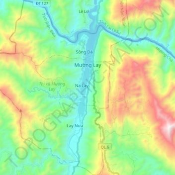
Name: Mường Lay topographic map, elevation, terrain.
Location: Mường Lay, Điện Biên Province, Vietnam (21.95826 103.04550 22.10138 103.19160)
Average elevation: 2,280 ft
Minimum elevation: 545 ft
Maximum elevation: 6,037 ft
Thank you for supporting this site ❤️
Make a donation
Make a donation
Gear up for your next adventure:
As an Amazon Associate, this site earns from qualifying purchases at no extra cost to you.
Other topographic maps
Click on a map to view its topography, its elevation and its terrain.
Bản Mường Nhé
Vietnam > Điện Biên Province > Mường Nhé District > Muong Nhe
Average elevation: 1,929 ft