
Make a donation
Gear up for your next adventure:
As an Amazon Associate, this site earns from qualifying purchases at no extra cost to you.
Pillow topographic map
Click on the map to display elevation.
Make a donation
Gear up for your next adventure:
As an Amazon Associate, this site earns from qualifying purchases at no extra cost to you.
About this map
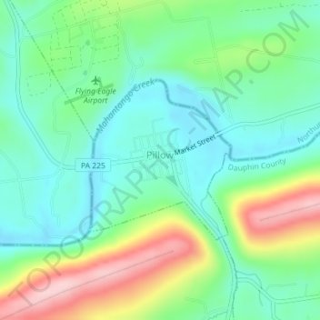
Name: Pillow topographic map, elevation, terrain.
Location: Pillow, Dauphin County, Pennsylvania, 17080, United States (40.63374 -76.81040 40.64724 -76.79457)
Average elevation: 676 ft
Minimum elevation: 456 ft
Maximum elevation: 1,148 ft
Dauphin County trails, hiking, mountain biking, running and outdoor activities
Make a donation
Gear up for your next adventure:
As an Amazon Associate, this site earns from qualifying purchases at no extra cost to you.
Other topographic maps
Click on a map to view its topography, its elevation and its terrain.
Singersville
United States > Pennsylvania > Dauphin County > Middle Paxton Township
Average elevation: 614 ft
Rockville
United States > Pennsylvania > Dauphin County > Susquehanna Township
Average elevation: 463 ft
Shellsville
United States > Pennsylvania > Dauphin County > East Hanover Township
Average elevation: 476 ft
Make a donation
Gear up for your next adventure:
As an Amazon Associate, this site earns from qualifying purchases at no extra cost to you.
Manada Gap
United States > Pennsylvania > Dauphin County > East Hanover Township
Average elevation: 666 ft
Montrose Park
United States > Pennsylvania > Dauphin County > Susquehanna Township
Average elevation: 344 ft
Piketown
United States > Pennsylvania > Dauphin County > West Hanover Township
Average elevation: 640 ft
Make a donation
Gear up for your next adventure:
As an Amazon Associate, this site earns from qualifying purchases at no extra cost to you.
Powells Valley
United States > Pennsylvania > Dauphin County > Halifax Township
Average elevation: 587 ft
Hanoverdale
United States > Pennsylvania > Dauphin County > West Hanover Township
Average elevation: 469 ft
Heckton
United States > Pennsylvania > Dauphin County > Middle Paxton Township
Average elevation: 509 ft
Make a donation
Gear up for your next adventure:
As an Amazon Associate, this site earns from qualifying purchases at no extra cost to you.
Hoernerstown
United States > Pennsylvania > Dauphin County > South Hanover Township
Average elevation: 433 ft
Killinger
United States > Pennsylvania > Dauphin County > Upper Paxton Township
Average elevation: 577 ft
Grantville
United States > Pennsylvania > Dauphin County > East Hanover Township
Average elevation: 469 ft
Make a donation
Gear up for your next adventure:
As an Amazon Associate, this site earns from qualifying purchases at no extra cost to you.
Fisherville
United States > Pennsylvania > Dauphin County > Jackson Township
Average elevation: 604 ft
Union Deposit
United States > Pennsylvania > Dauphin County > South Hanover Township
Average elevation: 410 ft
Wiconisco
United States > Pennsylvania > Dauphin County > Wiconisco Township
Average elevation: 1,083 ft
Bachmanville
United States > Pennsylvania > Dauphin County > Conewago Township
Average elevation: 541 ft
Make a donation
Gear up for your next adventure:
As an Amazon Associate, this site earns from qualifying purchases at no extra cost to you.
Beaufort Farms
United States > Pennsylvania > Dauphin County > Susquehanna Township
Average elevation: 430 ft
Make a donation
Gear up for your next adventure:
As an Amazon Associate, this site earns from qualifying purchases at no extra cost to you.
Carsonville
United States > Pennsylvania > Dauphin County > Jefferson Township
Average elevation: 886 ft
Edgemont
United States > Pennsylvania > Dauphin County > Susquehanna Township
Average elevation: 453 ft
Lenkerville
United States > Pennsylvania > Dauphin County > Upper Paxton Township
Average elevation: 512 ft
Make a donation
Gear up for your next adventure:
As an Amazon Associate, this site earns from qualifying purchases at no extra cost to you.
Twin Lakes Park
United States > Pennsylvania > Dauphin County > Twin Lakes Park
Average elevation: 479 ft
Locust Lane Gardens
United States > Pennsylvania > Dauphin County > Colonial Park > Locust Lane Gardens
Average elevation: 482 ft
Loyalton
United States > Pennsylvania > Dauphin County > Washington Township
Average elevation: 781 ft
Make a donation
Gear up for your next adventure:
As an Amazon Associate, this site earns from qualifying purchases at no extra cost to you.