Geolocate

Nelson topographic map

Click on the map to display elevation.

About this map

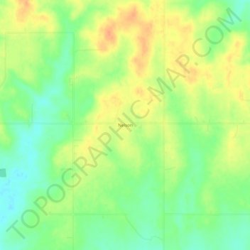
Name: Nelson topographic map, elevation, terrain.

Location: Nelson, Choctaw County, Oklahoma, United States (34.10732 -95.70525 34.14732 -95.66525)

Average elevation: 600 ft

Minimum elevation: 538 ft

Maximum elevation: 659 ft

Choctaw County trails, hiking, mountain biking, running and outdoor activities

Other topographic maps

Click on a map to view its topography, its elevation and its terrain.

Fort Towson

United States > Oklahoma > Choctaw County

Average elevation: 472 ft

Sawyer

United States > Oklahoma > Choctaw County

Average elevation: 440 ft

Soper

United States > Oklahoma > Choctaw County

Average elevation: 525 ft

Gear up for your next adventure:

🦶Hiking Gaiters - Keep debris and water out of your boots
🥾Men's Hiking Boots - Durable, waterproof footwear for rugged terrain and steep inclines
🎒Hydration Pack - Hands‑free water reservoir for long hikes
📱Solar Portable Charger - Solar power bank for charging devices off‑grid
🛶Inflatable Kayak - Portable kayak for rivers, lakes, and expeditions

As an Amazon Associate, this site earns from qualifying purchases at no extra cost to you.