
Make a donation
Gear up for your next adventure:
As an Amazon Associate, this site earns from qualifying purchases at no extra cost to you.
Kingstown topographic map
Click on the map to display elevation.
Make a donation
Gear up for your next adventure:
As an Amazon Associate, this site earns from qualifying purchases at no extra cost to you.
About this map
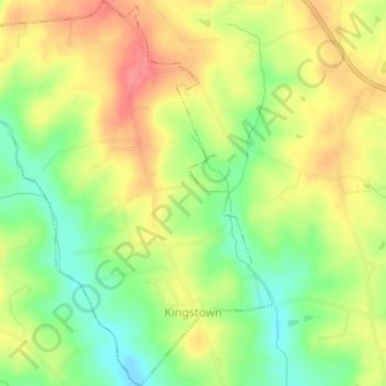
Name: Kingstown topographic map, elevation, terrain.
Location: Kingstown, Cleveland County, North Carolina, United States (35.34546 -81.63699 35.37557 -81.60478)
Average elevation: 909 ft
Minimum elevation: 791 ft
Maximum elevation: 1,017 ft
Cleveland County trails, hiking, mountain biking, running and outdoor activities
Make a donation
Gear up for your next adventure:
As an Amazon Associate, this site earns from qualifying purchases at no extra cost to you.
Other topographic maps
Click on a map to view its topography, its elevation and its terrain.
Make a donation
Gear up for your next adventure:
As an Amazon Associate, this site earns from qualifying purchases at no extra cost to you.
Osborne Apartments
United States > North Carolina > Cleveland County > Shelby
Average elevation: 840 ft