Geolocate

Spile topographic map

Click on the map to display elevation.

About this map

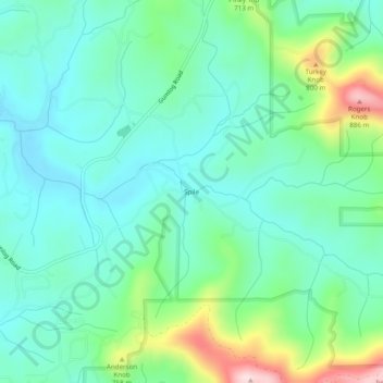
Name: Spile topographic map, elevation, terrain.

Location: Spile, Union County, Georgia, United States (34.91453 -83.99963 34.95453 -83.95963)

Average elevation: 2,119 ft

Minimum elevation: 1,841 ft

Maximum elevation: 2,946 ft

Union County trails, hiking, mountain biking, running and outdoor activities

Other topographic maps

Click on a map to view its topography, its elevation and its terrain.

Meeks Park

United States > Georgia > Union County

Average elevation: 1,847 ft

Vogel State Park

United States > Georgia > Union County

Average elevation: 2,749 ft

Gear up for your next adventure:

🔥Camping Stove - Portable stove for camping and backcountry cooking
🪵Folding Camp Saw - Compact saw for wood and campsite work
🪄Magnetic Compass - Accurate compass for navigation
🎁Geography Themed Gifts - Unique gift ideas for map lovers and geography enthusiasts
Backpacking Tents - Weight-optimized shelters for multi-day topographic surveys

As an Amazon Associate, this site earns from qualifying purchases at no extra cost to you.