
Make a donation
Gear up for your next adventure:
As an Amazon Associate, this site earns from qualifying purchases at no extra cost to you.
Peggau topographic map
Click on the map to display elevation.
Make a donation
Gear up for your next adventure:
As an Amazon Associate, this site earns from qualifying purchases at no extra cost to you.
About this map
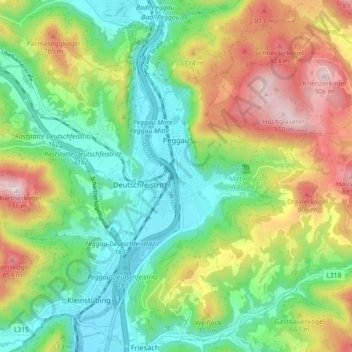
Name: Peggau topographic map, elevation, terrain.
Location: Peggau, Bezirk Graz-Umgebung, Stiermarken, 8120, Oostenrijk (47.17008 15.31989 47.23108 15.37826)
Average elevation: 1,913 ft
Minimum elevation: 1,260 ft
Maximum elevation: 3,035 ft
Make a donation
Gear up for your next adventure:
As an Amazon Associate, this site earns from qualifying purchases at no extra cost to you.
Other topographic maps
Click on a map to view its topography, its elevation and its terrain.
Sankt Marein bei Graz
Oostenrijk > Stiermarken > Bezirk Graz-Umgebung > St. Marein bei Graz
Average elevation: 1,296 ft
Make a donation
Gear up for your next adventure:
As an Amazon Associate, this site earns from qualifying purchases at no extra cost to you.