
Make a donation
Gear up for your next adventure:
As an Amazon Associate, this site earns from qualifying purchases at no extra cost to you.
North Glengarry topographic map
Click on the map to display elevation.
Make a donation
Gear up for your next adventure:
As an Amazon Associate, this site earns from qualifying purchases at no extra cost to you.
About this map
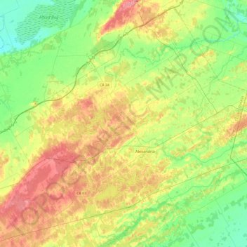
Name: North Glengarry topographic map, elevation, terrain.
Average elevation: 256 ft
Minimum elevation: 144 ft
Maximum elevation: 420 ft
Make a donation
Gear up for your next adventure:
As an Amazon Associate, this site earns from qualifying purchases at no extra cost to you.
Other topographic maps
Click on a map to view its topography, its elevation and its terrain.
Alexandria
Canada > Ontario > Stormont, Dundas and Glengarry Counties > North Glengarry
Average elevation: 276 ft
Moose Creek
Canada > Ontario > Stormont, Dundas and Glengarry Counties > North Stormont
Average elevation: 285 ft
McLaren Island
Canada > Ontario > Stormont, Dundas and Glengarry Counties > South Stormont > Ingleside
Average elevation: 243 ft
Dalkeith
Canada > Ontario > Stormont, Dundas and Glengarry Counties > North Glengarry
Average elevation: 230 ft
Make a donation
Gear up for your next adventure:
As an Amazon Associate, this site earns from qualifying purchases at no extra cost to you.
Tayside
Canada > Ontario > Stormont, Dundas and Glengarry Counties > North Stormont
Average elevation: 279 ft
Summerstown Station
Canada > Ontario > Stormont, Dundas and Glengarry Counties > South Glengarry
Average elevation: 177 ft
Winchester
Canada > Ontario > Stormont, Dundas and Glengarry Counties > North Dundas
Average elevation: 249 ft
North Lunenburg
Canada > Ontario > Stormont, Dundas and Glengarry Counties > South Stormont
Average elevation: 285 ft
Make a donation
Gear up for your next adventure:
As an Amazon Associate, this site earns from qualifying purchases at no extra cost to you.
South Mountain
Canada > Ontario > Stormont, Dundas and Glengarry Counties > North Dundas
Average elevation: 269 ft
Finch
Canada > Ontario > Stormont, Dundas and Glengarry Counties > North Stormont
Average elevation: 272 ft