Geolocate

Laza topographic map

Click on the map to display elevation.

About this map

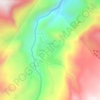
Name: Laza topographic map, elevation, terrain.

Location: Laza, Qusar District, Quba-Khachmaz, Azerbaijan (41.29316 48.10758 41.30077 48.11658)

Average elevation: 6,004 ft

Minimum elevation: 4,744 ft

Maximum elevation: 7,336 ft

Other topographic maps

Click on a map to view its topography, its elevation and its terrain.

Qusar District

Azerbaijan > Quba-Khachmaz

Average elevation: 3,533 ft

Khachmaz

Azerbaijan > Quba-Khachmaz > Khachmaz

Average elevation: 312 ft

Gear up for your next adventure:

🛠️Outdoor Gear Repair Kit - Essential tools to fix gear on the trail
🚪Portable Camp Chair - Foldable chair for comfort at camp
🧣Hiking Neck Gaiter - Multi‑use neck protection for outdoor weather
⛑️Personal Locator Beacon - Safety beacon for emergencies
🥾Men's Hiking Boots - Durable, waterproof footwear for rugged terrain and steep inclines

As an Amazon Associate, this site earns from qualifying purchases at no extra cost to you.