
Make a donation
Gear up for your next adventure:
As an Amazon Associate, this site earns from qualifying purchases at no extra cost to you.
Keiem topographic map
Click on the map to display elevation.
Make a donation
Gear up for your next adventure:
As an Amazon Associate, this site earns from qualifying purchases at no extra cost to you.
Keiem
Keiem ligt op de grens van het West-Vlaamse poldergebied en Zandlemig Vlaanderen op een hoogte van ongeveer 5 meter. Ten westen van Keiem bevindt zich de IJzervlakte. Hier loopt ook het Zijdelinggeleed, in noordwestelijke richting.
Make a donation
Gear up for your next adventure:
As an Amazon Associate, this site earns from qualifying purchases at no extra cost to you.
About this map
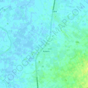
Name: Keiem topographic map, elevation, terrain.
Location: Keiem, Diksmuide, West-Vlaanderen, België (51.06591 2.83681 51.10697 2.91018)
Average elevation: 10 ft
Minimum elevation: -7 ft
Maximum elevation: 49 ft
Make a donation
Gear up for your next adventure:
As an Amazon Associate, this site earns from qualifying purchases at no extra cost to you.
Other topographic maps
Click on a map to view its topography, its elevation and its terrain.