
Make a donation
Gear up for your next adventure:
As an Amazon Associate, this site earns from qualifying purchases at no extra cost to you.
Arnoldsweiler topographic map
Click on the map to display elevation.
Make a donation
Gear up for your next adventure:
As an Amazon Associate, this site earns from qualifying purchases at no extra cost to you.
Arnoldsweiler
In der Nähe von Arnoldsweiler, und zwar westlich des Ortes und im Südostwinkel zwischen der A4 und der Bahnlinie Düren-Jülich bei der Höhe 120,6 befand sich eine nur beschränkt ausgebaute Batteriestellung der Luftverteidigungszone West. In der Hauptstellung konnten vier Unterstände nachgewiesen werden. Am Westrand der Bahnlinie fand man die Trümmer des MG-Schartenstandes.
Make a donation
Gear up for your next adventure:
As an Amazon Associate, this site earns from qualifying purchases at no extra cost to you.
About this map
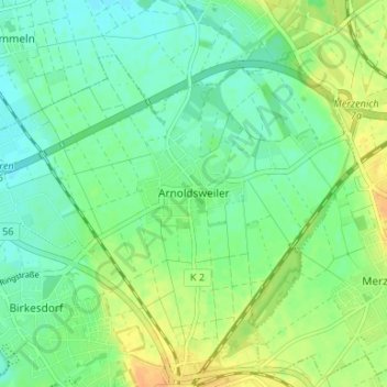
Name: Arnoldsweiler topographic map, elevation, terrain.
Average elevation: 400 ft
Minimum elevation: 361 ft
Maximum elevation: 459 ft
Make a donation
Gear up for your next adventure:
As an Amazon Associate, this site earns from qualifying purchases at no extra cost to you.
Other topographic maps
Click on a map to view its topography, its elevation and its terrain.
Gürzenich
Deutschland > Nordrhein-Westfalen > Kreis Düren > Düren
Vom 6. Oktober 1908 an wurde Gürzenich von der Straßenbahnlinie 3 der Dürener Kreisbahn (DKB) bedient. Die Strecke führte durch die heutige Valencienner Straße und die heutige Schillingsstraße und endete in Höhe der Kirche mit einem Umsetzgleis.
Average elevation: 440 ft