
Make a donation
Gear up for your next adventure:
As an Amazon Associate, this site earns from qualifying purchases at no extra cost to you.
Manvi topographic map
Click on the map to display elevation.
Make a donation
Gear up for your next adventure:
As an Amazon Associate, this site earns from qualifying purchases at no extra cost to you.
Manvi
Manvi is located in the Raichur district of Karnataka State, India. It has an administrative-limits area of 10 square kilometers (3.86 square miles) at an average elevation of 362 meters (1187 ft).
Make a donation
Gear up for your next adventure:
As an Amazon Associate, this site earns from qualifying purchases at no extra cost to you.
About this map
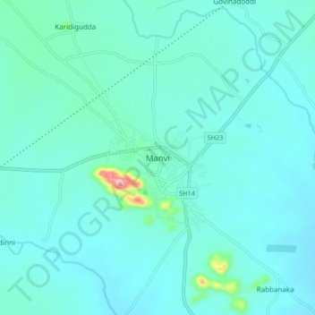
Name: Manvi topographic map, elevation, terrain.
Location: Manvi, Manvi taluku, Raichur, Karnataka, 584123, India (15.95675 77.00812 16.03675 77.08812)
Average elevation: 1,211 ft
Minimum elevation: 1,132 ft
Maximum elevation: 1,827 ft
Make a donation
Gear up for your next adventure:
As an Amazon Associate, this site earns from qualifying purchases at no extra cost to you.