Geolocate

Samcheong-dong topographic map

Click on the map to display elevation.

About this map

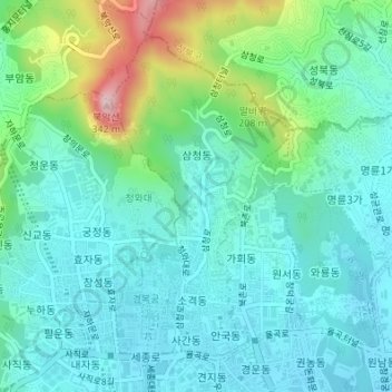
Name: Samcheong-dong topographic map, elevation, terrain.

Location: Samcheong-dong, Jongno-gu, Seoul, South Korea (37.57548 126.97368 37.59810 126.98905)

Average elevation: 312 ft

Minimum elevation: 95 ft

Maximum elevation: 1,050 ft

Gear up for your next adventure:

🧺Microfiber Travel Towels - Compact and fast-drying towels for trail use
🧭Orienteering Set - Complete compass and map reading kit
🪶Camp Gear Gift Set - Perfect gift bundle for outdoor fans
📱Heavy-Duty Phone Cases - Drop-proof and waterproof protection for outdoor navigation
📚USA Hiking Guide Books - Top trail guides and map books

As an Amazon Associate, this site earns from qualifying purchases at no extra cost to you.