
Serrote topographic map
Click on the map to display elevation.
About this map
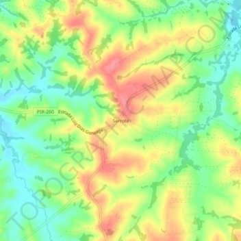
Name: Serrote topographic map, elevation, terrain.
Average elevation: 1,736 ft
Minimum elevation: 1,611 ft
Maximum elevation: 1,873 ft
Other topographic maps
Click on a map to view its topography, its elevation and its terrain.
Convívio Nosso Recanto
Brasil > São Paulo > Região Metropolitana de Piracicaba > Piracicaba
Average elevation: 1,880 ft
Vila Monteiro
Brasil > São Paulo > Região Metropolitana de Piracicaba > Piracicaba
Average elevation: 1,821 ft
Residencial Canadá
Brasil > São Paulo > Região Metropolitana de Piracicaba > Piracicaba
Average elevation: 1,601 ft
Praça "Neuza Carmem da Rocha Oliveira"
Brasil > São Paulo > Região Metropolitana de Piracicaba > Piracicaba
Average elevation: 1,680 ft
Rotatória "Recide Albertina Verdi Godinho"
Brasil > São Paulo > Região Metropolitana de Piracicaba > Piracicaba
Average elevation: 1,837 ft
Artemis
Brasil > São Paulo > Região Metropolitana de Piracicaba > Piracicaba
Average elevation: 1,693 ft