Geolocate

Thioux topographic map

Click on the map to display elevation.

About this map

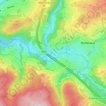
Name: Thioux topographic map, elevation, terrain.

Location: Thioux, Malmedy, Verviers, Liège, Wallonie, 4960, Belgique (50.36770 5.97255 50.40770 6.01255)

Average elevation: 1,289 ft

Minimum elevation: 928 ft

Maximum elevation: 1,778 ft

Gear up for your next adventure:

🎒Outdoor Daypacks - Lightweight backpacks designed for carrying maps and essential gear
📱Heavy-Duty Phone Cases - Drop-proof and waterproof protection for outdoor navigation
🪶Fire Starter Kit - Reliable fire starter for survival and camping
📻Weather Alert Radios - Stay informed of storm risks while off-the-grid
🗃️Trail First Aid Kit - Essential kit for outdoor injuries and emergencies

As an Amazon Associate, this site earns from qualifying purchases at no extra cost to you.