
Murchison topographic map
Click on the map to display elevation.
About this map
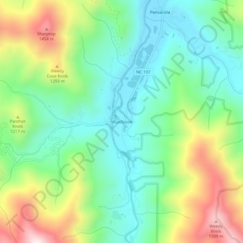
Name: Murchison topographic map, elevation, terrain.
Location: Murchison, Yancey County, North Carolina, United States (35.80984 -82.33596 35.84984 -82.29596)
Average elevation: 3,599 ft
Minimum elevation: 2,844 ft
Maximum elevation: 5,062 ft
Yancey County trails, hiking, mountain biking, running and outdoor activities
Other topographic maps
Click on a map to view its topography, its elevation and its terrain.