Geolocate

Ottawa topographic map

Click on the map to display elevation.

👉 Easily get elevation data in JSON, GeoTIFF and KML formats using Elevation API
Thank you for supporting this site ❤️
Make a donation

About this map

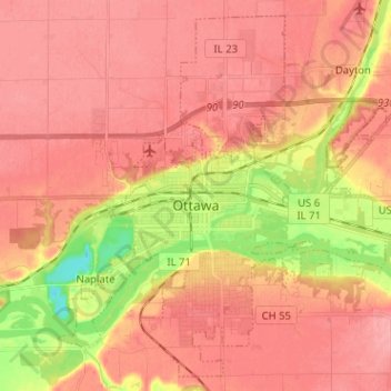
Name: Ottawa topographic map, elevation, terrain.

Location: Ottawa, LaSalle County, Illinois, 61350, United States (41.30969 -88.89043 41.39794 -88.76318)

Average elevation: 568 ft

Minimum elevation: 371 ft

Maximum elevation: 656 ft

LaSalle County trails, hiking, mountain biking, running and outdoor activities

Other topographic maps

Click on a map to view its topography, its elevation and its terrain.

Wedron

United States > Illinois > LaSalle County

Average elevation: 587 ft

Dayton

United States > Illinois > LaSalle County

Average elevation: 587 ft

Hitt

United States > Illinois > LaSalle County > Ottawa

Average elevation: 571 ft

Serena

United States > Illinois > LaSalle County

Average elevation: 630 ft

Gear up for your next adventure:

Camping Coffee Makers - Enjoy premium coffee at the summit or campsite
📷Action Cameras - Rugged cameras to document your journeys across rugged terrain
🎒Gear Packing Cubes - Organize your backpack efficiently
🧥Waterproof Jacket for Hiking - Breathable and rugged rain jacket for outdoor excursions
👓Polarized Sunglasses - Outdoor sunglasses for glare reduction

As an Amazon Associate, this site earns from qualifying purchases at no extra cost to you.