Geolocate

Bryan topographic map

Click on the map to display elevation.

About this map

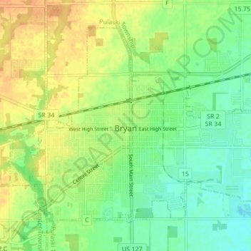
Name: Bryan topographic map, elevation, terrain.

Location: Bryan, Williams County, Ohio, 43506, United States (41.45550 -84.58376 41.49510 -84.51595)

Average elevation: 768 ft

Minimum elevation: 715 ft

Maximum elevation: 823 ft

Williams County trails, hiking, mountain biking, running and outdoor activities

Other topographic maps

Click on a map to view its topography, its elevation and its terrain.

Alvordton

United States > Ohio > Williams County > Alvordton

Average elevation: 850 ft

Melbern

United States > Ohio > Williams County

Average elevation: 843 ft

Columbia

United States > Ohio > Williams County > Northwest

Average elevation: 978 ft

Gear up for your next adventure:

🧥Waterproof Jacket for Hiking - Breathable and rugged rain jacket for outdoor excursions
🪑Portable Camp Table - Compact table for campsite meals
📱Solar Portable Charger - Solar power bank for charging devices off‑grid
🧤Tactile Hiking Gloves - Keep hands warm while operating GPS and smartphone screens
🩳Quick‑Dry Hiking Shorts - Comfortable and quick‑dry shorts for summer hiking

As an Amazon Associate, this site earns from qualifying purchases at no extra cost to you.