
Clarksville topographic map
Interactive map
Click on the map to display elevation.
About this map
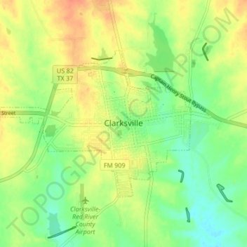
Name: Clarksville topographic map, elevation, terrain.
Location: Clarksville, Red River County, Texas, 75426, United States (33.59372 -95.10161 33.62703 -95.03460)
Average elevation: 433 ft
Minimum elevation: 367 ft
Maximum elevation: 502 ft
Other topographic maps
Click on a map to view its topography, its elevation and its terrain.
Greenwood
United States > Texas > Red River County
Greenwood, Red River County, Texas, United States
Average elevation: 397 ft
Boxelder
United States > Texas > Red River County
Boxelder, Red River County, Texas, United States
Average elevation: 361 ft
Bogata
United States > Texas > Red River County
Bogata, Red River County, Texas, 75417, United States
Average elevation: 417 ft
Albion
United States > Texas > Red River County
Albion, Red River County, Texas, United States
Average elevation: 381 ft