
Make a donation
Gear up for your next adventure:
As an Amazon Associate, this site earns from qualifying purchases at no extra cost to you.
Fuhlendorf topographic map
Click on the map to display elevation.
Make a donation
Gear up for your next adventure:
As an Amazon Associate, this site earns from qualifying purchases at no extra cost to you.
Fuhlendorf
Kennzeichen für Bodstedt ist die seit 1964 durchgeführte Zeesenbootregatta. Begründer war der Bodstedter Eckehard Rammin, der dann in Barth eine Bootswerft gründete. 2014 wurde vom 5. bis 7. September die 50. Regatta veranstaltet. Daran nahmen 54 Zeesboote teil (50 war das gesetzte Ziel). Ein Höhepunkt war die Einweihung des neuen Hafens mit Liegeplätzen für Zeesboote, Marina für Freizeitboote und Anleger für Fahrgastschiffe.
Make a donation
Gear up for your next adventure:
As an Amazon Associate, this site earns from qualifying purchases at no extra cost to you.
About this map
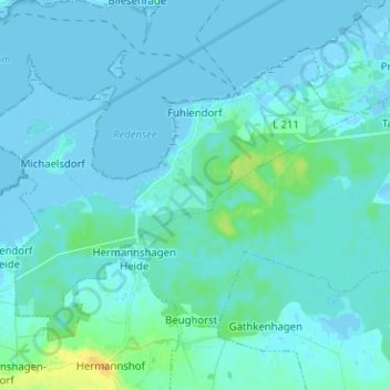
Name: Fuhlendorf topographic map, elevation, terrain.
Average elevation: 10 ft
Minimum elevation: -16 ft
Maximum elevation: 82 ft
Make a donation
Gear up for your next adventure:
As an Amazon Associate, this site earns from qualifying purchases at no extra cost to you.