Geolocate

Porter topographic map

Click on the map to display elevation.

About this map

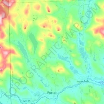
Name: Porter topographic map, elevation, terrain.

Location: Porter, Oxford County, Maine, 04068, United States (43.78499 -70.99228 43.88877 -70.88066)

Average elevation: 646 ft

Minimum elevation: 305 ft

Maximum elevation: 1,598 ft

Oxford County trails, hiking, mountain biking, running and outdoor activities

Other topographic maps

Click on a map to view its topography, its elevation and its terrain.

West Bethel

United States > Maine > Oxford County > Bethel

Average elevation: 827 ft

Record Hill

United States > Maine > Oxford County > Byron

Average elevation: 1,565 ft

Sunday River

United States > Maine > Oxford County > Bethel

Average elevation: 915 ft

Bryant Pond

United States > Maine > Oxford County > Woodstock

Average elevation: 886 ft

Grover Hill

United States > Maine > Oxford County

Average elevation: 817 ft

Old Speck Mountain

United States > Maine > Oxford County

Average elevation: 3,094 ft

Boston Hills

United States > Maine > Oxford County > Denmark

Average elevation: 446 ft

Sugarloaf

United States > Maine > Oxford County > Dixfield

Average elevation: 778 ft

Gear up for your next adventure:

📦Gear Storage Bags - Organize and protect outdoor equipment
🥄Camping Utensil Set - Lightweight utensils for outdoor meals
⛑️Personal Locator Beacon - Safety beacon for emergencies
🎒Gear Packing Cubes - Organize your backpack efficiently
🪶Thermal Camp Blanket - Extra warmth for cold nights

As an Amazon Associate, this site earns from qualifying purchases at no extra cost to you.