
Pereiaslav topographic map
Interactive map
Click on the map to display elevation.
About this map
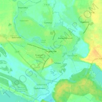
Name: Pereiaslav topographic map, elevation, terrain.
Average elevation: 308 ft
Minimum elevation: 276 ft
Maximum elevation: 361 ft
Other topographic maps
Click on a map to view its topography, its elevation and its terrain.
Tulyntsi
Tulyntsi, Myronivka Urban Hromada, Obukhiv Raion, Kyiv Oblast, 08822, Ukraine
Average elevation: 528 ft
Khotsky
Khotsky, Циблівська сільська громада, Boryspil Raion, Kyiv Oblast, 08473, Ukraine
Average elevation: 420 ft
Chornobyl
Chornobyl, Vyshhorod Raion, Kyiv Oblast, 07270, Ukraine
Average elevation: 371 ft
Nemishaieve
Nemishaieve, Nemishaeve Settlement Hromada, Bucha district, Kyiv Oblast, 07853, Ukraine
Average elevation: 525 ft
Novyi Korohod
Novyi Korohod, Borodianka Settlement Hromada, Bucha district, Kyiv Oblast, 07843, Ukraine
Average elevation: 515 ft
Fastiv
Fastiv, Fastiv Urban Hromada, Fastiv Raion, Kyiv Oblast, Ukraine
Average elevation: 617 ft
Kodra
Kodra, Makariv Settlement Hromada, Bucha district, Kyiv Oblast, 08010, Ukraine
Average elevation: 518 ft
Поліська селищна громада
Поліська селищна громада, Vyshhorod Raion, Kyiv Oblast, Ukraine
Average elevation: 449 ft
Урочище Оболонь
Ukraine > Kyiv Oblast > Pereiaslav
Урочище Оболонь, Гребля, Заальтиця, Pereiaslav, Переяславська міська громада, Boryspil Raion, Kyiv Oblast, 08400, Ukraine
Average elevation: 302 ft
Vasylkiv
Vasylkiv, Vasylkiv Urban Hromada, Obukhiv Raion, Kyiv Oblast, 08600-08606, Ukraine
Average elevation: 574 ft
Chernobyl Radiation and Ecological Biosphere Reserve
Chernobyl Radiation and Ecological Biosphere Reserve, Kyiv Oblast, 255340, Ukraine
Average elevation: 433 ft
Brovary
Brovary, Броварська міська громада, Brovary Raion, Kyiv Oblast, 07400, Ukraine
Average elevation: 417 ft
Irpin
Irpin, Irpin Urban Hromada, Bucansky district, Kyiv Oblast, Ukraine
Average elevation: 433 ft
Boryspil
Boryspil, Бориспільська міська громада, Boryspil Raion, Kyiv Oblast, Ukraine
Average elevation: 381 ft
Yahotyn
Ukraine > Kyiv Oblast > Yahotyn
Yahotyn, Яготинська міська громада, Boryspil Raion, Kyiv Oblast, 07700-07705, Ukraine
Average elevation: 404 ft
Vyshhorod
Ukraine > Kyiv Oblast > Vyshhorod
Vyshhorod, Вишгород, Vyshhorod Urban Hromada, Vyshhorod Raion, Kyiv Oblast, 07300, Ukraine
Average elevation: 407 ft
Bila Tserkva
Bila Tserkva, Bila Tserkva Urban Hromada, Bila Tserkva Raion, Kyiv Oblast, Ukraine
Average elevation: 571 ft
Vyshhorod
Vyshhorod, Vyshhorod Urban Hromada, Vyshhorod Raion, Kyiv Oblast, Ukraine
Average elevation: 404 ft
The Cliff Pond
Ukraine > Kyiv Oblast > Bila Tserkva
The Cliff Pond, Spruce Avenue, Піонерська, Bila Tserkva, Kyiv Oblast, 09100-09117, Ukraine
Average elevation: 541 ft
Vasylkiv
Ukraine > Kyiv Oblast > Vasylkiv
Vasylkiv, Kyiv Oblast, 08600-08606, Ukraine
Average elevation: 561 ft
Shpendivka
Shpendivka, Kaharlyk Urban Hromada, Obukhiv Raion, Kyiv Oblast, 09244, Ukraine
Average elevation: 587 ft