Geolocate

Sid Richardson Scout Ranch topographic map

Click on the map to display elevation.

About this map

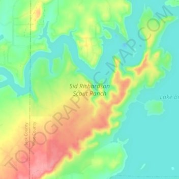
Name: Sid Richardson Scout Ranch topographic map, elevation, terrain.

Location: Sid Richardson Scout Ranch, Lake Bridgeport, Wise County, Texas, 76426, United States (33.19527 -97.91991 33.25764 -97.85522)

Average elevation: 906 ft

Minimum elevation: 807 ft

Maximum elevation: 1,083 ft

Wise County trails, hiking, mountain biking, running and outdoor activities

Other topographic maps

Click on a map to view its topography, its elevation and its terrain.

Gear up for your next adventure:

🔌Solar Panel Charger - Charge gear sustainably outdoors
🪶Compact Camp Shovel - Folding shovel for campsite tasks
🪶Camping Sleeping Pad - Comfortable sleeping pad for backpacking
🪓Survival Multi‑Tool - Versatile tool for camp and trail tasks
🦺Reflective Outdoor Gear - Safety gear for low‑light conditions

As an Amazon Associate, this site earns from qualifying purchases at no extra cost to you.