Geolocate

Navapark topographic map

Click on the map to display elevation.

About this map

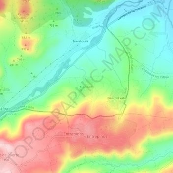
Name: Navapark topographic map, elevation, terrain.

Location: Navapark, Navahondilla, Ávila, Castile and León, 28648, Spain (40.30618 -4.48657 40.34618 -4.44657)

Average elevation: 2,467 ft

Minimum elevation: 2,142 ft

Maximum elevation: 2,923 ft

Gear up for your next adventure:

💧Water Purification System - Clean water on the trail with reliable purifiers
🧭Map Reading Tools - Tools and kits for map navigation
📶Vehicle Signal Boosters - Improve reception in rural areas while driving to trailheads
🪵Folding Camp Saw - Compact saw for wood and campsite work
🎒Hydration Pack - Hands‑free water reservoir for long hikes

As an Amazon Associate, this site earns from qualifying purchases at no extra cost to you.