
Make a donation
Gear up for your next adventure:
As an Amazon Associate, this site earns from qualifying purchases at no extra cost to you.
Falkenstein topographic map
Click on the map to display elevation.
Make a donation
Gear up for your next adventure:
As an Amazon Associate, this site earns from qualifying purchases at no extra cost to you.
Falkenstein
The linear settlement is located along an old pass road that reaches its highest elevation at 464 m (1522 ft). The village's main street is one of the steepest public roads in Germany with a 25% gradient. Along the road to Winnweiler the Falkensteiner Tal (Falkenstein Valley), known for its rock formations is situated. Most of the district is forested.
Make a donation
Gear up for your next adventure:
As an Amazon Associate, this site earns from qualifying purchases at no extra cost to you.
About this map
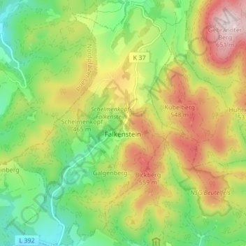
Name: Falkenstein topographic map, elevation, terrain.
Average elevation: 1,352 ft
Minimum elevation: 768 ft
Maximum elevation: 2,129 ft
Make a donation
Gear up for your next adventure:
As an Amazon Associate, this site earns from qualifying purchases at no extra cost to you.