
Make a donation
Gear up for your next adventure:
As an Amazon Associate, this site earns from qualifying purchases at no extra cost to you.
Parque del Este topographic map
Click on the map to display elevation.
Make a donation
Gear up for your next adventure:
As an Amazon Associate, this site earns from qualifying purchases at no extra cost to you.
About this map
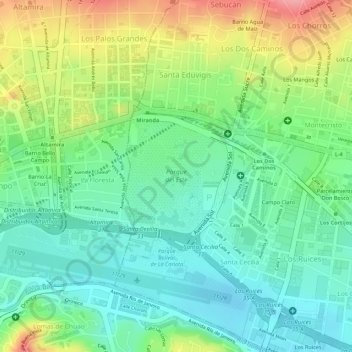
Name: Parque del Este topographic map, elevation, terrain.
Average elevation: 2,871 ft
Minimum elevation: 2,730 ft
Maximum elevation: 3,104 ft
Make a donation
Gear up for your next adventure:
As an Amazon Associate, this site earns from qualifying purchases at no extra cost to you.
Other topographic maps
Click on a map to view its topography, its elevation and its terrain.
Parque Miguel José Sanz
Venezuela > Estado Miranda > Municipio Sucre > Caracas
Average elevation: 2,884 ft
Pico Naiguatá
Venezuela > Estado Miranda > Municipio Sucre > Caracas
El pico Naiguatá es el más elevado de la Cordillera de la Costa. Se encuentra ubicado en el borde entre los estados de Miranda y La Guaira, en el sector centro-occidental del Parque nacional El Ávila al norte de la ciudad de Caracas, Venezuela. Su nombre proviene del pueblo de Naiguatá ubicado en la costa…
Average elevation: 7,398 ft
Make a donation
Gear up for your next adventure:
As an Amazon Associate, this site earns from qualifying purchases at no extra cost to you.