
Make a donation
Gear up for your next adventure:
As an Amazon Associate, this site earns from qualifying purchases at no extra cost to you.
Localidad Riomar topographic map
Click on the map to display elevation.
Make a donation
Gear up for your next adventure:
As an Amazon Associate, this site earns from qualifying purchases at no extra cost to you.
About this map
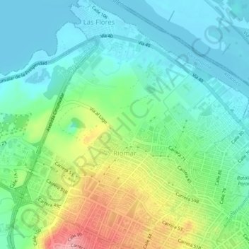
Name: Localidad Riomar topographic map, elevation, terrain.
Average elevation: 125 ft
Minimum elevation: 0 ft
Maximum elevation: 420 ft
Make a donation
Gear up for your next adventure:
As an Amazon Associate, this site earns from qualifying purchases at no extra cost to you.
Other topographic maps
Click on a map to view its topography, its elevation and its terrain.
Parque San Pio
Colombia > Atlántico > Barranquilla > Perímetro Urbano Barranquilla
Average elevation: 167 ft
Parque Santander
Colombia > Atlántico > Barranquilla > Perímetro Urbano Barranquilla
Average elevation: 128 ft
Bulevar de Simón Bolívar
Colombia > Atlántico > Barranquilla > Perímetro Urbano Barranquilla
Average elevation: 69 ft
Parque La Solución
Colombia > Atlántico > Barranquilla > Perímetro Urbano Barranquilla
Average elevation: 102 ft
Make a donation
Gear up for your next adventure:
As an Amazon Associate, this site earns from qualifying purchases at no extra cost to you.
Parque Montecristo
Colombia > Atlántico > Barranquilla > Perímetro Urbano Barranquilla
Average elevation: 66 ft
Parque San Salvador
Colombia > Atlántico > Barranquilla > Perímetro Urbano Barranquilla
Average elevation: 75 ft