
Make a donation
Gear up for your next adventure:
As an Amazon Associate, this site earns from qualifying purchases at no extra cost to you.
Orba Co topographic map
Click on the map to display elevation.
Make a donation
Gear up for your next adventure:
As an Amazon Associate, this site earns from qualifying purchases at no extra cost to you.
Orba Co
Orba Co, also Wo Erba or Wo Erbacuo (Chinese: 窝尔巴错; pinyin: Wōěrbā cuò; Tibetan: འོར་པ་མཚོ, Wylie: 'or pa mtsho), is a lake in Rutog County in the Ngari Prefecture in the northwest of the Tibet Autonomous Region of China. It lies at an elevation of 5,209 metres (17,090 ft), to the southeast of Longmu Lake.
Make a donation
Gear up for your next adventure:
As an Amazon Associate, this site earns from qualifying purchases at no extra cost to you.
About this map
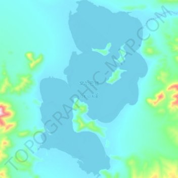
Name: Orba Co topographic map, elevation, terrain.
Location: Orba Co, Dongru, Rutog County, Ngari Prefecture, Tibet, China (34.45150 80.97800 34.60450 81.09300)
Average elevation: 17,211 ft
Minimum elevation: 17,028 ft
Maximum elevation: 19,131 ft
Make a donation
Gear up for your next adventure:
As an Amazon Associate, this site earns from qualifying purchases at no extra cost to you.
Other topographic maps
Click on a map to view its topography, its elevation and its terrain.