
Thank you for supporting this site ❤️
Make a donation
Make a donation
Gear up for your next adventure:
As an Amazon Associate, this site earns from qualifying purchases at no extra cost to you.
Townsend topographic map
Click on the map to display elevation.
Thank you for supporting this site ❤️
Make a donation
Make a donation
Gear up for your next adventure:
As an Amazon Associate, this site earns from qualifying purchases at no extra cost to you.
About this map
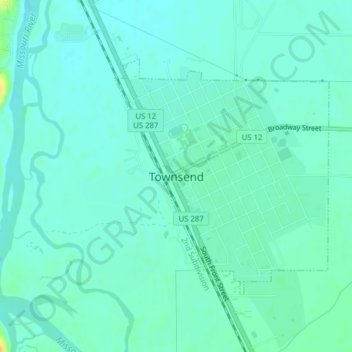
Name: Townsend topographic map, elevation, terrain.
Location: Townsend, Broadwater County, Montana, United States (46.31004 -111.52772 46.32817 -111.50385)
Average elevation: 3,825 ft
Minimum elevation: 3,802 ft
Maximum elevation: 3,901 ft
Broadwater County trails, hiking, mountain biking, running and outdoor activities
Thank you for supporting this site ❤️
Make a donation
Make a donation
Gear up for your next adventure:
As an Amazon Associate, this site earns from qualifying purchases at no extra cost to you.