
Mdina topographic map
Interactive map
Click on the map to display elevation.
About this map
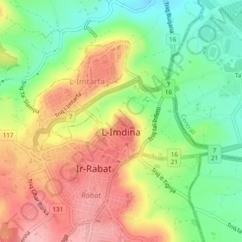
Name: Mdina topographic map, elevation, terrain.
Location: Mdina, Northern Region, Malta (35.88252 14.39728 35.89182 14.41535)
Average elevation: 489 ft
Minimum elevation: 279 ft
Maximum elevation: 715 ft
Other topographic maps
Click on a map to view its topography, its elevation and its terrain.
Dingli Cliffs
Malta > Northern Region > Dingli
Dingli Cliffs, Dingli, Northern Region, Malta
Average elevation: 420 ft
Saint Paul's Bay
Malta > Northern Region > Saint Paul's Bay
Saint Paul's Bay, Northern Region, Malta
Average elevation: 184 ft
Baħar iċ-Ċagħaq
Malta > Northern Region > Naxxar > Baħar iċ-Ċagħaq
Baħar iċ-Ċagħaq, Naxxar, Northern Region, NXR 9038, Malta
Average elevation: 128 ft
L-Imġarr
Malta > Northern Region > L-Imġarr
L-Imġarr, Northern Region, MGR 1502, Malta
Average elevation: 315 ft