
Egham topographic map
Click on the map to display elevation.
About this map
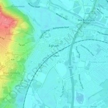
Name: Egham topographic map, elevation, terrain.
Location: Egham, Borough of Runnymede, Surrey, England, United Kingdom (51.42219 -0.56124 51.43615 -0.53753)
Average elevation: 82 ft
Minimum elevation: 33 ft
Maximum elevation: 289 ft
Other topographic maps
Click on a map to view its topography, its elevation and its terrain.
Cooper's Hill Slopes
United Kingdom > England > Surrey > Borough of Runnymede > Englefield Green
Average elevation: 125 ft
Chertsey
United Kingdom > England > Surrey > Borough of Runnymede
Samuel Lewis devotes one of his longest entries to the small town in his 1848 topographical guide to England.
Average elevation: 72 ft
Egham Wick
United Kingdom > England > Surrey > Borough of Runnymede > Englefield Green
Average elevation: 180 ft
Lyn Mushroom Farm
United Kingdom > England > Surrey > Borough of Runnymede > Lyne
Average elevation: 128 ft
Chertsey
United Kingdom > England > Surrey > Borough of Runnymede
Samuel Lewis devotes one of his longest entries to the small town in his 1848 topographical guide to England.
Average elevation: 72 ft