
Thank you for supporting this site ❤️
Make a donation
Make a donation
Gear up for your next adventure:
As an Amazon Associate, this site earns from qualifying purchases at no extra cost to you.
Azache topographic map
Click on the map to display elevation.
Thank you for supporting this site ❤️
Make a donation
Make a donation
Gear up for your next adventure:
As an Amazon Associate, this site earns from qualifying purchases at no extra cost to you.
About this map
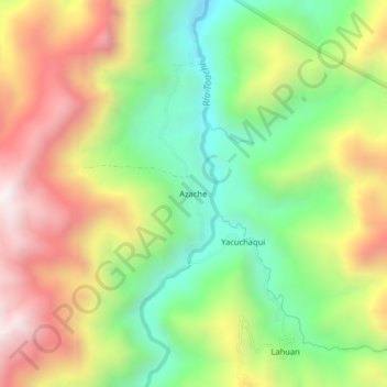
Name: Azache topographic map, elevation, terrain.
Location: Azache, Sigchos, Cotopaxi, Ecuador (-0.60200 -78.94286 -0.56200 -78.90286)
Average elevation: 6,667 ft
Minimum elevation: 5,102 ft
Maximum elevation: 8,566 ft
Thank you for supporting this site ❤️
Make a donation
Make a donation
Gear up for your next adventure:
As an Amazon Associate, this site earns from qualifying purchases at no extra cost to you.