
Make a donation
Gear up for your next adventure:
As an Amazon Associate, this site earns from qualifying purchases at no extra cost to you.
Srirangapatna topographic map
Click on the map to display elevation.
Make a donation
Gear up for your next adventure:
As an Amazon Associate, this site earns from qualifying purchases at no extra cost to you.
Srirangapatna
Srirangapatna is at 12°25′N 76°42′E / 12.41°N 76.7°E / 12.41; 76.7. It has an average elevation of 679 metres (2227 feet). Srirangapatna Sangama is the confluence of the three holy streams creating the island. Located 27 km upstream from the town is the spectacular Shivanasamudra Falls, the second biggest waterfall in India and the 16th largest in the world.
Make a donation
Gear up for your next adventure:
As an Amazon Associate, this site earns from qualifying purchases at no extra cost to you.
About this map
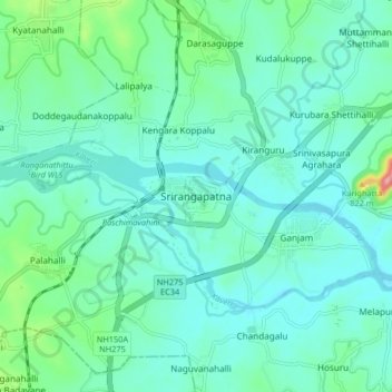
Name: Srirangapatna topographic map, elevation, terrain.
Average elevation: 2,274 ft
Minimum elevation: 2,182 ft
Maximum elevation: 2,703 ft
Make a donation
Gear up for your next adventure:
As an Amazon Associate, this site earns from qualifying purchases at no extra cost to you.
Other topographic maps
Click on a map to view its topography, its elevation and its terrain.
Ranganathittu Bird Sanctuary
India > Karnataka > Srirangapattana taluk > Krishnarajasagara
Average elevation: 2,415 ft
Krishnaraja Sagara Dam
India > Karnataka > Srirangapattana taluk > Krishnarajasagara
Average elevation: 2,428 ft