Geolocate

Orono topographic map

Click on the map to display elevation.

About this map

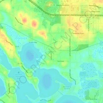
Name: Orono topographic map, elevation, terrain.

Location: Orono, Hennepin County, Minnesota, 55356, United States (44.95135 -93.62440 44.99135 -93.58440)

Average elevation: 968 ft

Minimum elevation: 915 ft

Maximum elevation: 1,063 ft

Hennepin County trails, hiking, mountain biking, running and outdoor activities

Gear up for your next adventure:

👖Convertible Hiking Pants - Versatile zip-off pants for changing altitudes and temperatures
🪶Compact Camp Shovel - Folding shovel for campsite tasks
🔊Portable Camp Speaker - Music and alerts at camp
🧥Men's Rain Shells - Premium waterproof and breathable jackets for mountain weather
🛰️Satellite Messengers - Emergency SOS and two-way messaging for off-grid adventures

As an Amazon Associate, this site earns from qualifying purchases at no extra cost to you.