
Thank you for supporting this site ❤️
Make a donation
Make a donation
Gear up for your next adventure:
As an Amazon Associate, this site earns from qualifying purchases at no extra cost to you.
Ballindalloch topographic map
Click on the map to display elevation.
Thank you for supporting this site ❤️
Make a donation
Make a donation
Gear up for your next adventure:
As an Amazon Associate, this site earns from qualifying purchases at no extra cost to you.
About this map
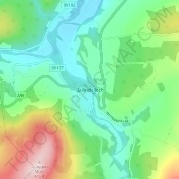
Name: Ballindalloch topographic map, elevation, terrain.
Location: Ballindalloch, Moray, Scotland, AB37 9YF, United Kingdom (57.38634 -3.38297 57.42634 -3.34297)
Average elevation: 764 ft
Minimum elevation: 423 ft
Maximum elevation: 1,552 ft
Thank you for supporting this site ❤️
Make a donation
Make a donation
Gear up for your next adventure:
As an Amazon Associate, this site earns from qualifying purchases at no extra cost to you.