
Granada topographic map
Click on the map to display elevation.
Granada
Granada (/ɡrəˈnɑːdə/ grə-NAH-də, Spanish: , locally ) is the capital city of the province of Granada, in the autonomous community of Andalusia, Spain. Granada is located at the foot of the Sierra Nevada mountains, at the confluence of four rivers, the Darro, the Genil, the Monachil and the Beiro. Ascribed to the Vega de Granada comarca, the city sits at an average elevation of 738 m (2,421 ft) above sea level, yet is only one hour by car from the Mediterranean coast, the Costa Tropical. Nearby is the Sierra Nevada Ski Station, where the FIS Alpine World Ski Championships 1996 were held.
About this map
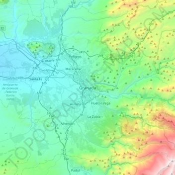
Name: Granada topographic map, elevation, terrain.
Average elevation: 3,422 ft
Minimum elevation: 1,759 ft
Maximum elevation: 10,328 ft