
Thank you for supporting this site ❤️
Make a donation
Make a donation
Gear up for your next adventure:
As an Amazon Associate, this site earns from qualifying purchases at no extra cost to you.
Ibis topographic map
Click on the map to display elevation.
Thank you for supporting this site ❤️
Make a donation
Make a donation
Gear up for your next adventure:
As an Amazon Associate, this site earns from qualifying purchases at no extra cost to you.
About this map
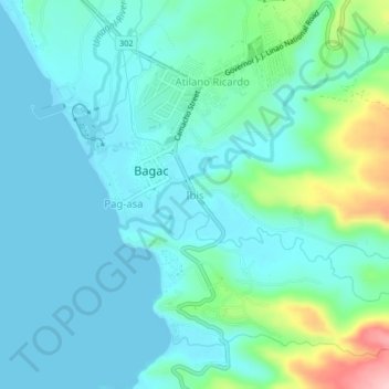
Name: Ibis topographic map, elevation, terrain.
Location: Ibis, Bagac, Bataan, Central Luzon, 2107, Philippines (14.57426 120.37698 14.61426 120.41698)
Average elevation: 115 ft
Minimum elevation: 0 ft
Maximum elevation: 600 ft
Thank you for supporting this site ❤️
Make a donation
Make a donation
Gear up for your next adventure:
As an Amazon Associate, this site earns from qualifying purchases at no extra cost to you.