
Thank you for supporting this site ❤️
Make a donation
Make a donation
Gear up for your next adventure:
As an Amazon Associate, this site earns from qualifying purchases at no extra cost to you.
Hanzhuang topographic map
Click on the map to display elevation.
Thank you for supporting this site ❤️
Make a donation
Make a donation
Gear up for your next adventure:
As an Amazon Associate, this site earns from qualifying purchases at no extra cost to you.
About this map
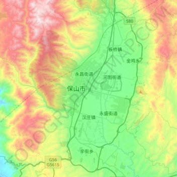
Name: Hanzhuang topographic map, elevation, terrain.
Location: Hanzhuang, Longyang District, Baoshan, Yunnan, China (25.00735 99.01834 25.22034 99.31003)
Average elevation: 6,519 ft
Minimum elevation: 4,534 ft
Maximum elevation: 9,948 ft
Thank you for supporting this site ❤️
Make a donation
Make a donation
Gear up for your next adventure:
As an Amazon Associate, this site earns from qualifying purchases at no extra cost to you.