
Thank you for supporting this site ❤️
Make a donation
Make a donation
Gear up for your next adventure:
As an Amazon Associate, this site earns from qualifying purchases at no extra cost to you.
Asfaux topographic map
Click on the map to display elevation.
Thank you for supporting this site ❤️
Make a donation
Make a donation
Gear up for your next adventure:
As an Amazon Associate, this site earns from qualifying purchases at no extra cost to you.
About this map
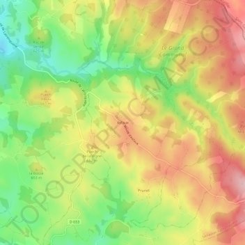
Name: Asfaux topographic map, elevation, terrain.
Average elevation: 2,083 ft
Minimum elevation: 1,736 ft
Maximum elevation: 2,411 ft
Thank you for supporting this site ❤️
Make a donation
Make a donation
Gear up for your next adventure:
As an Amazon Associate, this site earns from qualifying purchases at no extra cost to you.
Other topographic maps
Click on a map to view its topography, its elevation and its terrain.
Le Tolerme
France > Occitanie > Lot > Sénaillac-Latronquière
Le Tolerme prend sa source vers 650 mètres d'altitude, dans le Quercy, sur la commune de Labastide-du-Haut-Mont.
Average elevation: 1,873 ft