
Make a donation
Gear up for your next adventure:
As an Amazon Associate, this site earns from qualifying purchases at no extra cost to you.
Sable Lake topographic map
Click on the map to display elevation.
Make a donation
Gear up for your next adventure:
As an Amazon Associate, this site earns from qualifying purchases at no extra cost to you.
About this map
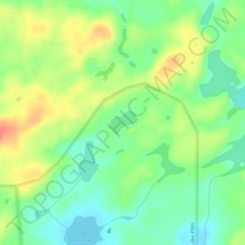
Name: Sable Lake topographic map, elevation, terrain.
Location: Sable Lake, Lake County, Minnesota, United States (47.96605 -91.28872 47.96869 -91.28391)
Average elevation: 1,598 ft
Minimum elevation: 1,526 ft
Maximum elevation: 1,696 ft
Lake County trails, hiking, mountain biking, running and outdoor activities
Make a donation
Gear up for your next adventure:
As an Amazon Associate, this site earns from qualifying purchases at no extra cost to you.
Other topographic maps
Click on a map to view its topography, its elevation and its terrain.
Boundary Waters Canoe Area Wilderness
United States > Minnesota > Lake County
Average elevation: 1,388 ft
Make a donation
Gear up for your next adventure:
As an Amazon Associate, this site earns from qualifying purchases at no extra cost to you.