
Make a donation
Gear up for your next adventure:
As an Amazon Associate, this site earns from qualifying purchases at no extra cost to you.
Palmyra topographic map
Click on the map to display elevation.
Make a donation
Gear up for your next adventure:
As an Amazon Associate, this site earns from qualifying purchases at no extra cost to you.
About this map
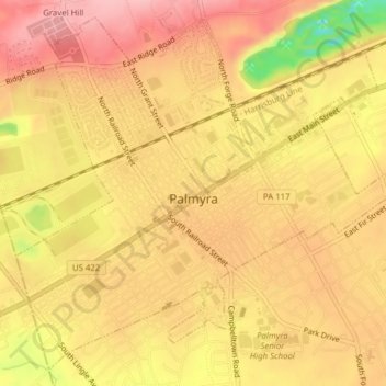
Name: Palmyra topographic map, elevation, terrain.
Location: Palmyra, Lebanon County, Pennsylvania, United States (40.29561 -76.61113 40.32279 -76.57232)
Average elevation: 459 ft
Minimum elevation: 157 ft
Maximum elevation: 604 ft
Lebanon County trails, hiking, mountain biking, running and outdoor activities
Make a donation
Gear up for your next adventure:
As an Amazon Associate, this site earns from qualifying purchases at no extra cost to you.
Other topographic maps
Click on a map to view its topography, its elevation and its terrain.
Sunset
United States > Pennsylvania > Lebanon County > North Lebanon Township
Average elevation: 591 ft
Lights Dam
United States > Pennsylvania > Lebanon County > North Lebanon Township > Ebenezer
Average elevation: 551 ft
Fort Indiantown Gap
United States > Pennsylvania > Lebanon County > Union Township
Average elevation: 712 ft
Lights Dam
United States > Pennsylvania > Lebanon County > North Lebanon Township > Ebenezer
Average elevation: 551 ft
Make a donation
Gear up for your next adventure:
As an Amazon Associate, this site earns from qualifying purchases at no extra cost to you.
Woodfort
United States > Pennsylvania > Lebanon County > North Cornwall Township
Average elevation: 472 ft