Geolocate

Collingtree topographic map

Click on the map to display elevation.

About this map

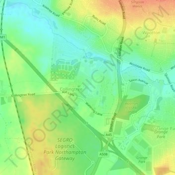
Name: Collingtree topographic map, elevation, terrain.

Location: Collingtree, West Northamptonshire, England, United Kingdom (52.18609 -0.91016 52.20281 -0.89199)

Average elevation: 282 ft

Minimum elevation: 217 ft

Maximum elevation: 358 ft

Gear up for your next adventure:

🔭Compact Binoculars - HD vision for scouting terrain and identifying distant landmarks
🛡️Insect Repellent - Protection against bugs during outdoor activities
🕶️GPS Smartphone Mount - Secure mount for phone navigation
🌐World Map Poster - Decorative world maps with topographic info
🧦Hiking Socks - Comfortable socks to prevent blisters on long hikes

As an Amazon Associate, this site earns from qualifying purchases at no extra cost to you.