Geolocate

Quito topographic map

Click on the map to display elevation.

About this map

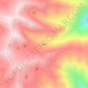
Name: Quito topographic map, elevation, terrain.

Location: Quito, Luis Carranza, Provincia de La Mar, Ayacucho, Perú (-13.31565 -73.92864 -13.27565 -73.88864)

Average elevation: 13,251 ft

Minimum elevation: 10,673 ft

Maximum elevation: 14,278 ft

Gear up for your next adventure:

🏕️Family Camping Gear - Essentials for group camping trips
🔪Outdoor Multitools - Essential survival tools for gear repair and field use
💧Water Purification System - Clean water on the trail with reliable purifiers
🦺Reflective Outdoor Gear - Safety gear for low‑light conditions
👓Polarized Sunglasses - Outdoor sunglasses for glare reduction

As an Amazon Associate, this site earns from qualifying purchases at no extra cost to you.